

Provinces of Costa Rica

Ready to Explore
- San Jose — features the culturally rich and diverse national capital.
- Heredia — Due north of San Jose, up to the Nicaraguan border.
- Alajuela — West of Heredia, to the Nicaraguan border. Features Volcan Poás National Park.
- Guanacaste — The northwest part of the country. One of the most diverse regions of the country, and the world, with cloud forests, active volcanoes, national parks and five-star beach resorts.

- Puntarenas — Covers most of the Pacific coast and its lowlands, from near the most western parts of Costa Rica (due west of San Jose,) down to the Panamanian border (actually southeast of San Jose) including the Manuel Antonio national park.
- Limon — The Caribbean east coast of the country. Features banana plantations, several biological reserves and national parks, and a largely Jamaican-rooted bilingual population.
- Cartago — Northeast of San Jose. Home of many of the volcanoes that enrich the soil of the meseta.
San Jose, Province – Costa Rica
The City is one of the youngest capital cities in latin america and in the center of all political and economic activies in Costa Rica. The that end, is often referred to as the cradle of commerce, art and architecture for the country.
Learn MoreCLIMATE:
The province of San Jose includes areas representative of practically every climatic regime possible in Costa Rica since its territory extends from almost sea level at several points near the central Pacific coast up to the country’s highest peak, Mt. Chirripó, at an elevation of 3,820 m. Additionally, a small portion of the province protrudes down the very wet eastern slopes of the Central Volcanic Cordillera in a section of Braulio Carrillo National Park. Thus, the entire range of temperatures and rainfall patterns that affect Costa Rica can be experienced somewhere in the province. Nonetheless, the majority of the province of San Jose is blessed by a moderate climate where nothing more than a sweater or lightweight jacket and an umbrella are all the protection from the elements you’ll ever need. This mild climatic region lies in an altitudinal band between 700 and 1300 meters above sea level and is under the influence of a distinct dry season from mid-November through mid-May and a corresponding wet season during the remaining half of the year — the characteristic weather pattern for essentially all of the nation’s territory on the western side of the continental divide.
HISTORY:
The province of San José is the most populated of Costa Rica’s seven provinces and is the seat of the nation’s capital, the city of San José. In the early years of the Central Valley’s colonization (1560’s), families began spreading west from the village of Cartago, and one of the first places settled was the valley of Aserrí (to the south of what is now the city of San José). Some 170 years later, in 1736, the authorities ordered the inhabitants of the valley of Aserrí to move to a site known as “Boca del Monte” and to this end erected a church dedicated to Saint Joseph, which was finished in 1738 — on a site which is across the street from the east side of what is now the Central Bank. The parish became known as “San José de la Boca del Monte en el Valle de Aserrí”. Due to problems with lack of water in the immediate area around the church, however, the inhabitants of Aserrí refused to move to the new site. In 1751, water was finally piped to the area, also known as Villa Nueva, but the residents of Aserrí still had to be almost forced to at last move to the new town.By 1824, the population of San José had grown to more than 15,000 and a year earlier the city had become the capital of the newly independent country — this came after a brief civil war over whether to remain independent (a view backed by residents of San José and Alajuela) or become a part of the Mexican empire (supported by the citizens of Cartago and Heredia). Following the victory of those favoring independence, the capital was moved from Cartago to San Jose.
NATIONAL PARKS:
1) Braulio Carrillo National Park
2) Chirripó National Park
3) Carara Biological Reserve
Heredia, Province – Costa Rica
Heredia is also known for its amazing colonial architecture that can be admired throughout. One of the main attractions in Heredia City is the historic church La Immaculada Concepcion, built in 1976 with a solid time-tested foundation and bells that originate from Peru.
Learn MoreCLIMATE:
Like the province of Alajuela, Heredia includes a portion of the Central Valley and the Central Volcanic Cordillera, but the majority of its territory lies in the northern lowlands, south of Nicaragua. The geographical variation contained within this province (the smallest of Costa Rica’s seven) gives it as wide a range of climatic conditions as any of the provinces, from warm and humid lowlands, to cool and damp highlands, to the mild but seasonally wet and dry Central Valley.
HISTORY:
Within less than a decade after the founding of the Spanish settlement in the Valley of Cartago, other areas in the Central Valley also began to be colonized. Among the first of these areas was the village of Barva — less than three kilometers north of what is now the city of Heredia.
With the introduction of coffee to Costa Rica, the fertile southern slopes of Barva Volcano became populated with plantations of this crop. The steep and very rainy northern slope did not become populated until much more recently. The Sarapiquí River, which is navigable upstream from the San Juan River (which flows into the Caribbean) as far inland as Puerto Viejo (Old Port) de Sarapiquí at the volcano’s base on the northern side, was an important transportation route for those few hardy settlers who first moved into this region.
NATIONAL PARKS:
1) Braulio Carrillo National Park (Barva Volcano sector)
2) Barra Colorado National Wildlife Refuge.
Alajuela, Province – Costa Rica
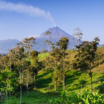
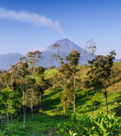
Alajuela is replete with many natural treasures, most of them being garded in different natural areas. Arenal Volcano, Poas Volcano and Tenorio Volcano are some of the most visited national parks in the province. It should be noted, that the capital city of this province is Alajuela.
Learn MoreCLIMATE:
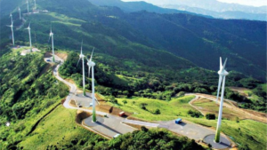
Many associate Alajuela with the warm and sunny climate that characterizes the city of the same name and the various towns in the western end of the Central Valley that also belong to this large and populous province. However, the vast majority of the provincial territory lies on the other side of the volcanic cordilleras, extending north to the Nicaraguan border. This sprawling area in the northern lowlands is under the influence of weather conditions coming in off the Caribbean Sea and was formerly covered in extensive tracts of majestic rain forest. Recent agricultural colonization of the northern frontier has severely altered the natural landscape (witness the paucity of national parks in the region), and very likely has affected the climate to some degree, resulting in hotter and slightly drier conditions, even though this is still an area of high annual rainfall (local inhabitants claim it rains 13 months out of the year). Even wetter, and much cooler, conditions exist along the Caribbean-facing slopes of the cordilleras, which reach a height of 2,704 meters above sea level on the summit of Poás Volcano.
HISTORY:
Following the establishment of the city of Cartago in the latter part of the 16th century, the incipient population began expanding westward. By the beginning of the 18th century, the population of Heredia had grown such that it became a second base of expansion, again to the west.
In the last few decades, with an extensive network of all-weather roads constructed in this once isolated region, cattle and crop production have come to dominate the countryside and a thriving agricultural economy now exists which supplies much of the nation’s corn, beans, and fruit and vegetable produce.
NATIONAL PARKS:
1) Caño Negro National Wildlife Refuge
2) Arenal National Park
3) Poás Volcano National Park
4) Juan Castro Blanco National Park.
Guanacaste, Province – Costa Rica
Guanacaste’s terrain is flat, with some exceptions such as the nicoya peninsula. Guanacaste is divided into 11 cities, and Liberia is the capital of the province. The Guanacaste Tree is Costa Rica’s national tree.
Learn MoreCLIMATE:
The weather throughout the province of Guanacaste is characterized by being hot with well-defined wet and dry seasons. The one exception is the highland portion of the province which consists of the upper Pacific-facing slopes of the volcanoes in the Guanacaste Cordillera and the northern half of the Tilarán Cordillera. The cool, moist conditions along these ridges support luxuriant cloud forests. Elsewhere, the natural vegetation type originally found in Guanacaste is (was) tropical dry forest.
The annual dry season is caused by the effects of the northeast trade winds that blow in off the Caribbean from November through March. This humid air loses its moisture as it crosses the Caribbean lowlands and the cordilleras. Given that the Guanacaste Cordillera is both the lowest and narrowest in the country, there is little to block the passage of the arid air that comes gusting down the western slopes drying out everything in its path, as well as preventing any breezes from bringing in moist air from the Pacific Ocean during these months.
When the trade winds shift northward, air currents once again bring humidity and life-giving rains in from the Pacific Ocean. It is remarkable to observe how quickly the parched and brown countryside regains its verdant appearance after the first showers of each new rainy season. In Guanacaste, these afternoon showers usually return by mid-May and continue until about mid-November.
HISTORY:
The pre-Columbian inhabitants of Guanacaste are noted for the fine quality pottery that they produced. The variety of ceramic vessels found at archeological sites has led investigators to theorize the existence of a well-developed system of agriculture, and specifically grain production. The fact that as yet no evidence of hunter-gather societies has been unearthed in the region, has been a motive for speculating that the first humans to settle here already possessed a working knowledge of agriculture.
During colonial times, Guanacaste did not actually form part of the province of Costa Rica, but instead pertained to Nicaragua. Shortly after the nations in the region gained their independence from Spain in 1821, the residents of the communities of Nicoya, Santa Cruz, and Cañas decided that they preferred to become part of Costa Rica and announced their annexation on July 25, 1825. This date is commemorated by a government holiday, even though it was not until 1858 that the change in boundary lines was officially recognized and agreed upon by the two countries involved.
NATIONAL PARKS:
1) Isla Bolaños Biological Reserve
2) Santa Rosa National Park
3) Guanacaste National Park
4) Rincón de la Vieja National Park
5) Barra Honda National Park
6) Palo Verde National Park
7) Lomas Barbudal Biological Reserve
8) Las Baulas Marine National Park
9) Tamarindo National Wildlife Refuge
10) Ostional National Wildlife Refuge
Puntarenas, Province – Costa Rica
The province’s capital city is Puntarenas. It is situated on a long, narrow peninsula in the gulf of nicoya. Though the beach may be seem a bit urban, many visitors enjoy the liveliness that is Puntarenas, which is replete with waterfront restaurants, bars and cafes.
Learn MorePuntarenas was Costa Rica’s main port until Caldera Port, located 16 km to the south, became the most important port of call for many of the major cruise liners, as well as commercial ships. Caldera is now an industrial port complex for both cruise ships and cargo vessels. Its opening brought new industries, more tourists and helped to spur on further developments of the nation. Further, it also serves as the primary access point from the Pacific coast to the historic capital city of San Jose.
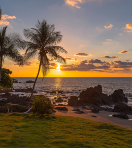
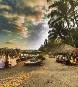
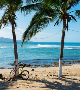
The province of Puntarenas has become one of the most important tourist destinations in the country. Many of Costa Rica’s most popular beach resorts are found in this province, as well as 14 national parks and reserves – more than in any other province.
CLIMATE:
Being Costa Rica’s largest province (11,277 sq. km.), Puntarenas includes practically all of the climate regimes found in this small, but tremendously varied, country. From tropical dry forest to rain forest, and from mangrove swamp to cloud forest to subalpine paramo, this sprawling province contains at least a little bit of everything.
Although the entire province lies on the Pacific side of the continental divide, much of its land area is not as severely affected by the annual dry season as is most of Guanacaste province (just to the north on the same side of the country). This is due to the topography’s effect on the prevailing winds. The northeast trade winds that come in off the Caribbean Sea are to some extent blocked by the higher mountains of the Central Volcanic and Talamanca Cordilleras before they reach much of the province (from the Carara Biological Reserve south); and once on the Pacific side, the turbulence formed in the passage results in a vortex, or reverse flow of air currents, that actually can draw in moist air from the Pacific Ocean and produce scattered rain showers even during the dry season. These occasional rains and associated high humidity keep the forested portions of the southern coastal areas (e.g., Manuel Antonio and Corcovado National Parks) green throughout the year, though some species of trees do briefly drop their leaves in response to the drier conditions from January through April.
In the interior sections of the province that reach up to the ridgeline, luxuriant cloud forests exist owing to the mists that sweep across the mountaintops when the tradewinds’ full effect is felt from December through February. Yet it is saddening to see how deforestation has advanced up the steep hillsides, in large part aided by the ease of burning the natural vegetation during the dry months of March and April.
HISTORY:
The peculiar shape of Puntarenas province has a very sensible explanation. During the first 350 years of Spanish presence in Central America, the southern Pacific portion of what is now Costa Rica remained quite isolated from the developing population centers of the region. The high mountains between this area and the Central Valley presented a formidable barrier to the available means of terrestrial transportation. Thus, the few early settlers that ventured into the southern region came either from Panama to the south, or by boat from the port of Caldera in the Gulf of Nicoya.
An important aspect of the provincial economy today is tourism. The country’s most popular beach resorts, Puntarenas (including Doña Ana and Barranca beaches), Jacó, and Manuel Antonio, are all found in this province, as are 14 national parks and reserves — more than in any other province.
NATIONAL PARKS:
1) Peñas Blancas National Wildlife Refuge
2) Guayabo, Negritos and Pájaros Islands Biological Reserves
3) Curú National Wildlife Refuge
4) Cabo Blanco Absolute Nature Reserve
5) Carara Biological Reserve
6) Manuel Antonio National Park
7) Ballena Marine National Park
8) La Amistad International Park
9) Corcovado National Park
10) Caño Island Biological Reserve
11) Golfito National Wildlife Refuge
12) Cocos Island National Park
Limon, Province – Costa Rica
The Limon Province consists of think tropical jungles, coconut trees, ornamental plants, beaches, small towns, and an assortement of villages, and banana plantations. Limon is a top spot for scientific and ecological tourism and studies. The capital city Limon has over 60,000 inhabitants, and is located on the caribbean coast.
Learn MoreCLIMATE:
Limón conjures up images of Costa Rica’s coconut-fringed Caribbean coast. Although the province does indeed extend the length of this coast — from the mouth of the San Juan River in the north, to the mouth of the Sixaola River on the Panamanian border — the southern sector includes a large area of mountainous terrain that stretches up to the country’s highest peak, Mt. Chirripó, in the Talamanca Cordillera. Likewise, the provincial boundaries also climb to over 2,000 m. elevation on the northeastern flank of Turrialba Volcano.
Despite the rise in elevation from sea level to 3,820 meters, Limón is the only one of Costa Rica’s seven provinces to be entirely on the Caribbean side of the Continental Divide, and thus its weather is directly affected by the flow of warm, moist air brought in off this body of water by the northeast trade winds. The result is a climate with no pronounced dry season, even though it does tend to be less rainy in the months of March, April, September, and October, and typically rains the most in June, July, August, November, and December. The lowland regions remain warm and humid year-round, while the higher portions are both cooler and wetter.
HISTORY:
Christopher Columbus, or Cristobal Colón as he is known in Spanish, and his crew were the first Europeans to lay eyes on the shores and forest-covered mountains of Costa Rica. On the great Admiral’s fourth and final voyage to the Americas, in 1502, he anchored near what is now the port city and provincial capital of Limón. His brief dealings with the native people he met on the mainland were apparently good-natured, yet this benevolent interaction was not to be the norm during the centuries to come.
Spanish settlement of Costa Rica came not from the Atlantic but from the Pacific side of the country. Given the mountainous barrier between the Central Valley and the Caribbean lowlands, as well as the dense forests and high rainfall characteristic of the latter region, would-be colonists were faced with a real challenge. The periodic expeditions organized with, at least in part, the purpose of establishing permanent settlements in the Caribbean region inevitably met with failure. Their cruel treatment of the indigenous people did not help the Spaniards in their objective either, since the natives in the area wholeheartedly resisted colonization.
Thus, throughout the three centuries of the colonial period, while the Central Valley and northern Pacific portions of Costa Rica were being progressively dominated by settlers from Spain, the Atlantic wilderness continued to be an untamed frontier.
The real opening of Costa Rica’s eastern frontier did not come until the second half of the 19th century. In 1867, the site for a Caribbean port was chosen, and it is said that growing on the spot was an old lemon tree, or limon.
To make the port accessible from the interior of the country, the government decided to construct a railroad and contracted the services of the North American entrepreneur, Minor Keith, in exchange for 300,000 hectares of land in the Caribbean lowlands, plus other benefits.
Keith established banana plantations on the land and brought in Afro-American workers from Jamaica to tend the plantations and build the railroad, thus changing not only the physical environment — which for thousands of years had been rain forest — but also the cultural milieu of the region.
NATIONAL PARKS:
1) Barra del Colorado National Wildlife Refuge
2) Tortuguero National Park
3) Braulio Carrillo National Park
4) Cahuita National Park
5) Gandoca – Manzanillo National Wildlife Refuge
6) La Amistad International Park
7) Hitoy – Cerere Biological Reserve
8) Chirripó National Park
Cartago, Province – Costa Rica
Cartago was formerely the capital city of Costa Rica until 1823, when the capital was changed to San Jose, making it the wealthiest province in colonial tradition.
Learn MoreCLIMATE:
This interior province consists primarily of the Reventazón River valley and the surrounding high mountains to the north (Irazú and Turrialba Volcanoes) and south (Cerro de la Muerte and Mount Chirripó) and is situated practically entirely on the Atlantic side of the continental divide. Therefore, the moisture brought in by the trade winds directly affects most of the province, although the city of Cartago itself is in the rain shadow of the 3,432 meter high Irazú Volcano and as a result is one of the driest parts of Costa Rica, after the lower portions of Guanacaste province. The overall high elevation of Cartago province and frequent cloud cover combine to impart relatively cool temperatures throughout the year
HISTORY:
The city of Cartago was first established in 1563 by the Spanish conquistador Juan Vásquez de Coronado. The original village was situated between the Coris and Purires Rivers, several kilometers to the southwest of the present day city. This location proved to be poorly chosen, however, since the settlement was flooded so often that it came to be known as the “City of Mud,” and in 1572 was transferred to another site closer to what is now San Jose.
About two years later, the population was again transferred back to the current site of the city of Cartago, which remained the capital of the province of Costa Rica throughout the colonial period. In 1823, two years after independence from Spain, the country’s governmental seat was moved to San Jose and Cartago was left to develop as a provincial capital of the new republic.
NATIONAL PARKS:
1) Irazú Volcano National Park
2) Tapantí National Park
3) Guayabo National Monument
4) Chirripó National Park
5) Braulio Carrillo National Park


